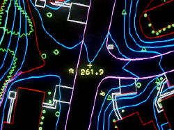
The softcopy workstations
are used to collect planimetric and topographic features directly from high-resolution scans of the aerial photography. Mapping
specifications can differ between each project, whether it be a 1"=40' scale highway corridor plan or a 1"=100' scale map
for a proposed residential subdivision. Topographic data is generated through the production of DTMs (Digital Terrain Models),
which are most helpful for cut/fill design programs. The staff at Minuteman Mapping has managed
every size project, from a small 10 acre subdivision to a 70 square mile municipal GIS land base map. Deliverable digital
files include AutoCAD and MicroStation formats.